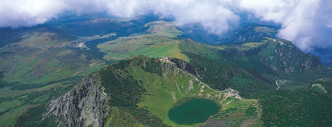
 The upper slopes of Hallasan. Gwaneumsa climbs the northern side, through a valley and up onto this ridge. ⓒWikimedia Commons · CC BY 2.0The upper slopes of Hallasan. Gwaneumsa climbs the northern side, through a valley and up onto this ridge. ⓒWikimedia Commons · CC BY 2.0
Hallasan › Gwaneumsa Trail (8.7 km to the summit)
Gwaneumsa is the shorter of the two trails to the summit of Hallasan and by a wide margin the harder. It is 8.7 km one way, about 5 hours up and roughly 10 hours for the round trip. The distance is a kilometre less than Seongpanak and the day is an hour longer, which tells you everything about the gradient. Experienced hikers mostly use it as the way down.
Last checked 2026-09-30 · Jeju Special Self-Governing Province (Hallasan National Park Office) · Korea Forest Service trail geodata · cross-checked against the Korean edition of this page
Gwaneumsa starts at the Gwaneumsa campground on the northern side of the mountain and goes up past Gurin-gul, through the Tamna valley, to Samgakbong shelter at 6 km, then 2.7 km more to the summit. That is 8.7 km one way against Seongpanak's 9.6 km. It also takes about 5 hours instead of 4 hours 30 minutes, and roughly 10 hours for the round trip instead of 9.
The reason is the valley. Where Seongpanak walks a long, even forest gradient, Gwaneumsa drops into and climbs out of a deep ravine and then puts the elevation on in concentrated stretches. The park rates it the hardest of the five trails. This is why the standard plan among Korean hikers is up Seongpanak, down Gwaneumsa: the gradient that punishes you on the way up is exactly what makes it a fast descent.
Both summit trails need a reservation for their upper section, so a Seongpanak-up, Gwaneumsa-down day means booking both. They are separate bookings, not one ticket for the mountain.
As on Seongpanak, the reservation covers only the top part of the trail: from Samgakbong shelter to the summit. The 6 km up to the shelter is open walking. If you have no booking you can still climb to Samgakbong, which is the most scenic part of the trail anyway, and turn round there.
Hallasan is run by Jeju Province rather than the Korea National Park Service, so it does not use the national reservation.knps.or.kr system that Seoraksan and the mainland parks use. Book through the Hallasan park office, and check the day's cut-off time, which changes with the season.
This is the single most important thing to check before you commit to Gwaneumsa. The section from Samgakbong to the summit was closed completely from 1 August to 30 September 2026. During that window it was not possible to reach Baengnokdam by this trail at all, whatever your booking said.
The dates above are the 2026 closure as published. Do not assume the same window applies to a later year, and do not assume it has reopened on schedule. Ring the trail office on ☎064-756-9950 or check the Hallasan park notices before you build a day around this route. If the upper section is shut, Seongpanak is the only way to the crater.
The compensation for the gradient is that Gwaneumsa is the more dramatic of the two trails. Seongpanak is a long walk in forest; Gwaneumsa gives you a lava tube, a ravine, and a high ridge with the summit dome in front of you for the last stretch. If you are fit and the weather is settled, it is the better day out. If you are not certain about your legs, it is the wrong choice.
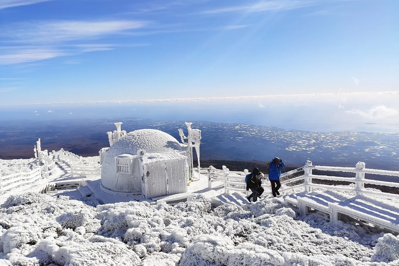
Baengnokdam, the crater lake, is about 1,720 m around the rim, about 108 m deep and about 550 m across. Those figures come from provincial and press sources and differ slightly between them, so treat them as approximate. Core sampling puts the last eruption at least 19,000 years ago. You reach the eastern rim and look down; walking to the water or around the rim is not allowed.
The height of Hallasan is quoted three ways. Aerial lidar in 2016 gave 1,947.06 m, the National Geographic Information Institute triangulation point reads 1,947.269 m, and older material still says 1,950 m. This site uses 1,947 m.
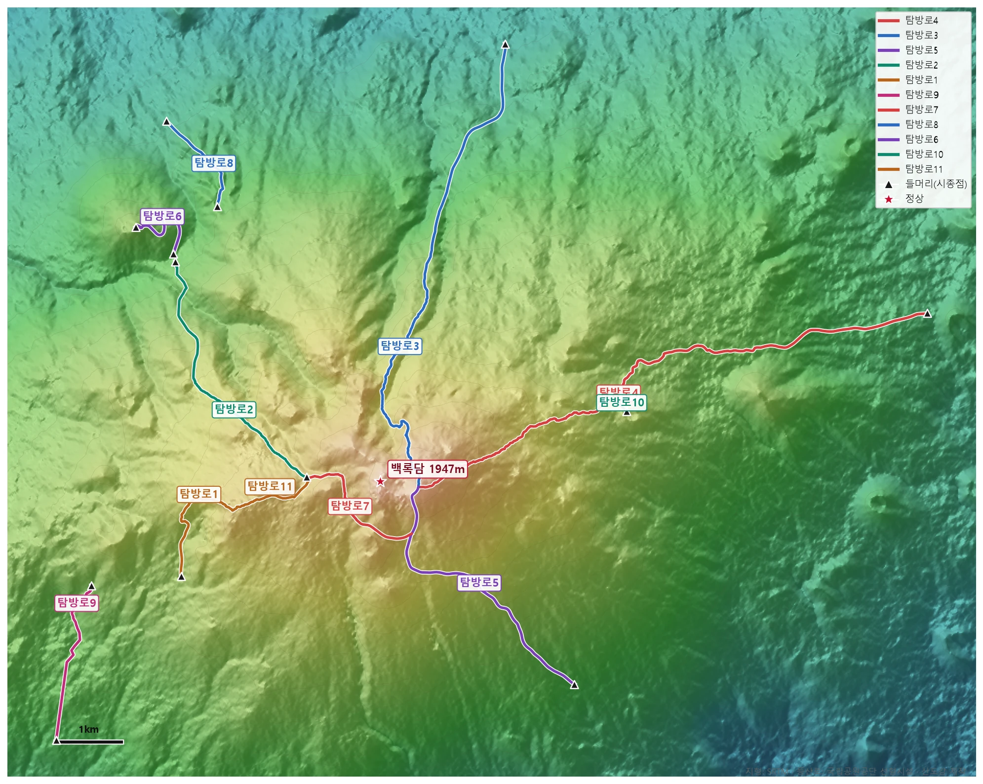
🗺 Open the full-size trail map
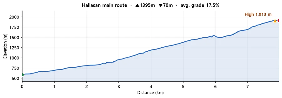
Calculated from SRTM terrain elevation (DEM) over 7.97 km. A moving average and a 4 m threshold are applied to damp GPS noise, so the figures run conservative rather than inflated. This is the mountain-wide profile for Hallasan drawn from Korea Forest Service trail geodata, not a track recorded on Gwaneumsa specifically. Use it for the scale of the climb rather than for turn-by-turn detail. The trail data can stop short of the summit, so the high point shown here may sit below the official 1,947 m.
For all five trails, the reservation rules, seasonal closures and the GPX download, see the Hallasan guide. The direct comparisons are Seongpanak, the other summit trail and the easier of the two, and Yeongsil, the shortest trail on the mountain, which stops below the crater.
Q. How hard is the Gwaneumsa trail?
It is rated the hardest of Hallasan's five trails. At 8.7 km one way it is shorter than Seongpanak's 9.6 km, but it takes about 5 hours up rather than 4 hours 30 minutes because it crosses a deep valley and gains elevation in concentrated stretches. Allow about 10 hours for the round trip.
Q. Do I need a reservation for Gwaneumsa?
Yes, for the section above Samgakbong shelter, which sits at the 6 km mark. The 6 km up to the shelter needs no booking. Hallasan is run by Jeju Province, so book through the Hallasan park office rather than the national reservation system used by mainland parks.
Q. Is the Gwaneumsa trail open?
Check before you go. The section from Samgakbong to the summit was closed completely from 1 August to 30 September 2026. Closures on this trail have been repeated and seasonal, so do not assume the same window applies in a later year or that it has reopened on schedule. Ring ☎064-756-9950 or check the park notices. If the upper section is shut, Seongpanak is the only route to the crater.
Q. Should I go up or down Gwaneumsa?
Down, if you have the choice. The usual plan is up Seongpanak and down Gwaneumsa, which puts the gentle gradient under fresh legs and the steep ground on the descent. It also means you see the forest side and the valley side of the mountain in one day. Both upper sections need their own reservation.
Q. What is there to see on the Gwaneumsa trail?
Gurin-gul, a lava tube on the lower slope, then the Tamna valley, which is the deep ravine that gives the trail its reputation, and then a high ridge with the summit dome ahead of you. It is the more dramatic of the two summit trails; Seongpanak is a long walk in forest by comparison.